
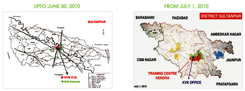
Sultanpur is an agrarian district of the eastern-plain zone of U.P.. It lies between 81032! and 82041! East longitude and 25059! And 25040! North latitude with geographical areas of 4436 km2. Initially district was divided into four sub-divisions and 19 blocks for administrative and development purposes. Later on it was again reorganize and finally divided into 7 sub divisions, 24 blocks, 187 Nyaya Panchayats comprising of 2,531 villages (1991). Again the district has been reorganized excluding 2 subdivisions, 10 blocks, 73 Nyaya Panchayats and 800 villages. At present district has 4 subdivisions, 14 blocks, 113 Nyaya Panchayats and 1731 Villages (July -2010).
| Particulars | Upto June 30, 2010 | From July 1, 2010 |
|---|---|---|
| Total Aera (Ha) | 439720 | 266366 |
| No of sub div. | 7 | 4 |
| Comm. Block no. | 24 | 14 |
| No of n. Panchyat | 187 | 114 |
| No. Of vill panchyat | 1262 | 805 |
| Total Population | 25.59 lac. | 20.58 lac. |
| Male | 13.23 lac. | 10.39 lac. |
| Female | 12.36 lac. | 10.18 lac. |
| Literacy | 7.94 lac. | 9.83 lac. |
Gomti is the only important river of the district . It enters in the district from North-West corner and runs in a well defined courses towards South-East and finally flows into Jaunpur district. The major portion of the district (49.33%) lies in the main basin of Gomti which drains about 17.67% of the total area. Apart from these, there are numbers of water bodies locally known as ‘tals’ which also play an important role.
The district has semiarid climate with temperature ranging from 50 to 230 C and upto 470 C the average annual rain fall is about 900 to 1000 mm and confined mainly during July to September. Hail and Dust Storms are observed only during March to June.
The soils of the district are farmed through alluvial deposits carried by river system comprising Ganga, Gomati and Its tributaries. Physiographic variations in the district has contributed to the development of soils of the different physical and chemical characteristics. A good proportion of land is beset with productive hazards such as water logging, erosion and sodicity. The major textured group of the soil in the district is sandy, sandy loam, loam and clay loam.
Out of the total geographical area, about 67% is devoted to Agriculture. The Culturable and non-culturalble waste land contributes 14.85 % and 18.21 % respectively.
89.0